Translate

Saturday, June 30, 2018

Get to the San Diego Zoo and Balboa Park By MTS Bus and Trolley!

updated June 30, 2018

The San Diego Zoo and Balboa Park are extremely easy to get to by bus! The San Diego Zoo is in Balboa Park.  I know you really want to take the Trolley there and avoid the bus altogether, but until that happens sometime in the distant future, you'll need to take Route 7 or Rapid Route 215.

Route 7 runs every 10 minutes all day long on weekdays and every 15 minutes on weekends (during Zoo hours). Route 215 runs every 10-15 minutes on weekdays and every 15 minutes on weekends.  The fare is $2.25 per person ($1.10 for senior/disabled) and children under 5 are free. On weekends, two children under the age of 12 ride free with each paying adult. If you are riding three or more transit vehicles on your round trip, purchase a $5 day pass* on the first vehicle you board or at the first Trolley station you visit (*-you need a Compass Card to actually pay $5.  Otherwise, you must pay $7 on board the bus for a paper pass).  You can also purchase your Day Pass in advance on your mobile phone with MTS's Compass Cloud app.  (see my fares page for more info)

From Downtown San Diego / South Bay / Trolley

Just board any Route 7 or Route 215 bus along eastbound Broadway in Downtown San Diego (at 3rd Ave., 5th Ave., etc.) and it will take you all the way to the Zoo and Balboa Park! Tell the driver you want the zoo stop (the bus announcement will say "Zoo Place - San Diego Zoo").  If you want Balboa Park, get off at the stop called "Village Place" or "El Prado."  If you are coming from South Bay or on the Trolley, transfer to the buses at City College on the 11th Avenue side of the station.

On the way back, the bus stops across the street and takes you back to City College/Broadway or to 10th Ave. where you can transfer to the Trolley.

From SDSU/El Cajon Blvd./Adams Ave.
Take Route 1 or 11 to Park Blvd. & University Ave. and transfer to a southbound Route 7 or Route 215.  You can also walk south on Park Blvd. from here but it is about 1 mile (1.2 km) away.

Take Route 215 all the way from SDSU or along El Cajon Blvd to the Zoo.

From La Jolla / University City / UCSD
  • Weekdays:  Take Route 30, 50 or 150 to any stop on Broadway in Downtown San Diego and then follow the Downtown instructions above.  
  • Weekends:  Take the Route 30 to Old Town and transfer to any Route 10 (destination El Cajon & College or I-15 & University).  Get off Route 10 at University Avenue & Park Blvd.  Transfer to a southbound Route 7 or Route 215 on Park Blvd. toward Downtown from there.  You can also walk south on Park Blvd. from here but it is about 1 mile (1.2 km) away.

From Old Town
  • Bus Only: Take any Route 10 (destination El Cajon & College or I-15 & University). Get off Route 10 at University Avenue & Park Blvd. Transfer to a southbound Route 7 or Route 215 on Park Blvd. toward Downtown from there. You can also walk south on Park Blvd. from here but it is about 1 mile (1.2 km) away. 
  • Trolley & Bus: Take the Green Line Trolley to Santa Fe Depot. Transfer to the Route 215 on Kettner Blvd. and it will take you all the way to the Zoo!

Get to the San Diego Beaches by Bus!

updated June 30, 2018

San Diego has many fabulous beaches - and almost all of them are reachable by bus. I'll visit a few ways to get to the beach by San Diego Metropolitan Transit System (MTS) bus. As much as you'd like to take the Trolley to the beach, it just doesn't go there so a bus will be involved.  Remember that if you don't have a monthly pass, buy a Day Pass for $5 if you're riding more than twice in a day (or $7 if you are paying cash on a bus without a Compass Card). MTS doesn't give free transfers. Also, MTS has a special fare for families - on weekends, two children under 12 ride free with a paying adult.

Always remember to plan your trip before you go by using Google Maps (just click on the bus icon when you plan your trip).  MTS has a great page that describes how to use Google Transit on their website or on your mobile phone.  You can also use the Google Transit trip planner built right into this blog.

Pacific Beach, Mission Beach, Mission Bay , and Mission Bay Park
Everybody loves Pacific Beach (PB)! PB has great beaches, plenty of volleyball courts, a very nice boardwalk, restaurants, and bars. It's a great place to tan, play Frisbee, volleyball, rollerblade, bike, or just walk around. Mission Beach (MB) is just as fun, and Mission Bay Park is a great place to have a day of fun near the water.

What's even better, there are four bus routes that serve this area. The core of these routes are the 8 and 9. Route 8 operates between Old Town Transit Center and the beach communities via Mission Bay Drive and Mission Blvd. The fare is $2.25 per trip (or $5 for a Day Pass including the Trolley). The routes each run every 15-20 minutes most of the day. You can bring your bike and your surf board!  Take the Trolley or bus to Old Town and transfer.

Route 30 operates between Downtown San Diego (on weekdays only), Old Town, the beaches, UCSD, and La Jolla/UTC. It operates every 15 minutes every day of the week. It's really the fastest way to get from Downtown San Diego and the beaches on weekdays. On weekends, catch Route 30 at Old Town Transit Center (you can take the Green Line from downtown San Diego). The fare is $2.25. Bikes are allowed.  Route 30 is the best way to get to the Banana Bungalow Hostel.

Route 27 operates between Kearny Mesa and Pacific Beach. It operates every 30 minutes on weekdays, every 60 minutes on Saturdays, but no service on Sundays. The fare is $2.25. Bikes are allowed on board.

Ocean Beach
Ocean Beach (OB) has great beaches, restaurants, and is a little more laid back than PB and MB. MTS Route 35 travels between Old Town and OB every 15 minutes on weekdays and every 30 minutes on weekends. It's a very popular route during the summer because it also connects OB'ers to the Midway shopping area and Kobe's swap meet.

Route 923 runs between Downtown San Diego and OB on weekdays with 30 minute service. It connects Downtown with the Airport, the Point Loma Hostel, the OB Hostel, and arrives just blocks from the beach in OB. Be careful - the route has limited hours on weekdays - don't get stuck after a few too many beers! On weekends, you can take Route 35 to/from Ocean Beach via Old Town Transit Center.

Coronado Beaches
Coronado has wonderful beaches! Take Route 901 from Downtown San Diego across the Coronado Bridge and get off at the Hotel del Coronado. Route 901 runs every 15-30 minutes on weekdays, every 30 minutes on Saturdays, and every hour on Sundays. You can also get to the beach by taking the Coronado Ferry and then transfer to Route 904 (the 904 is a free summer shuttle!).

Imperial Beach
While Imperial Beach (IB) isn't exactly world-renowned, it does have a beach area and a nice boardwalk. Take Routes 933/934 (6-15 minute service, seven days per week) from the Iris Trolley Station.

San Diego has so much to offer&emdash;and you can get there by bus!

Getting to the San Diego Airport (Lindbergh Field) via Trolley, COASTER and Bus

updated June 30, 2018

Did you know that it's easy to get to/from San Diego International Airport (Lindbergh Field) via public transportation? MTS's Route 992 is the Airport Shuttle.  I know you want to take a train to the airport, but there is no such connection in San Diego.  Plus, the bus drops you off right at each terminal (Terminal 1 & Terminal 2), just steps away from check in counters.

To get to the San Diego Airport (Lindbergh Field), take:
  • the COASTER to Santa Fe Depot
  • the Trolley Blue Line to America Plaza or Green Line to Santa Fe Depot (via foot, cross Kettner Blvd to America Plaza Trolley Station where the bus departs from)
  • the bus to any stop on Broadway in Downtown San Diego
  • the Trolley Green Line to Middletown Station and transfer to the Trolley to Terminal shuttle (free!) run by the San Diego airport at the stop just west of Pacific Highway and Palm.
The stop for Route 992 at America Plaza is on Broadway at Kettner next to Starbucks (across Kettner Blvd. from Santa Fe Depot). There's a bus shelter there with an "Airport Flyer" sign on the side. Service is every 15 minutes almost all day, seven days per week. The bus will take about 10-15 minutes from there to reach any airport terminal (Terminal 1 or Terminal 2).

The fare on Route 992 is $2.25 ($1.10 for seniors or disabled with ID). If you are boarding a Trolley or another bus first, keep in mind that there aren't any free transfers. If you are riding three or more vehicles to get to the airport, buy a Regional Day Pass for $5.00* when you board the first vehicle (*-you need a Compass Card to pay $5 otherwise you must pay $7 for a paper pass).

No Compass Card or cash, no problem!  Use MTS's Compass Cloud app to buy your Day Pass on your phone before you go (for $5).  You can also purchase NCTD COASTER tickets in the app if you are coming in via the COASTER!

If you work at the airport, buy a Regional Day Pass so you can use it coming back home. The Regional Day Pass expires at 2:30 a.m. the following day, so if you work after midnight, you can still use it (even though the 992 service stops earlier than midnight). If you travel on weekends, two children under the age of 12 ride free with each paying person over age 18 on the bus and trolley!  See my fares page for more information.

If you are starting your trip at the airport, MTS now has Ticket Vending Machines (TVM) in each airport terminal (as of February 2016).  Simply go to the TVM and purchase a Day Pass on Compass Card.  It's $5 if you already have a Compass Card, or $7 if you need to purchase a new Compass Card.  This will let you get on Route 992 and the Trolley or other bus lines.  The TVMs accept cash and credit cards, so it's a great way to start your trip.  You can also buy multi-day passes from the TVM at the airport (3, 4, 5, 14, and 30 day passes).  Don't forget MTS's Compass Cloud app to purchase your pass on your phone and avoid getting a Compass Card altogether.

To get back to downtown from the airport, catch the 992 bus at one of the three stops at the airport and it will take you to Broadway & Kettner (Santa Fe Depot/America Plaza) where you can catch the Trolley or COASTER. You can transfer to other bus routes all along Broadway if your trip requires another bus.

San Diego Airport's Free Trolley to Terminal Shuttle

You can take the Green Line Trolley to the Middletown Station.  Walk west on Palm St. and cross Pacific Highway.  Keep walking west toward the runways and then turn to the north at the end of Palm St. onto Admiral Boland Way and you will see a bus stop shelter to catch the free Trolley to Terminal Shuttle.  Not all buses stop at this stop - the buses that go to the Car Rental Center don't stop.  The smaller buses that serve long term parking are the buses that will pick you up.  Service runs every 15 minutes or so.  Coming back, you can do the same thing!


Make a Trip Plan Before You Go!
As always, I suggest that you make a personal trip plan for your trip to the airport.
  • Use Google Maps.  Click on the link, type in your starting address, date, and time at Google Maps' website.
  • Go to the MTS website's trip planner and type in your starting address, select Airport from the landmark list, and type in your ARRIVAL time at the airport. I would suggest putting in 30 minutes before you need to be there to have a cushion of time because buses do break down and things do go awry sometimes. You can also call 511 and the operators there will be glad to help you.

Friday, October 14, 2011

Find Bus Stop Numbers in San Diego

Updated March 5, 2016

Want to know what time the bus will get to your stop in San Diego for the Metropolitan Transit System?  It's easy!  All you need is a phone that has a texting capability.  MTS calls its system GO MTS! (http://www.sdmts.com/OnTheGo)


1)  Find your stop number.  Most bus stop blades have bus stop numbers on them:

2)  Text the stop number to GOMTS (46687).  You'll receive a reply shortly with times of arrival for that stop.

  • Some buses in San Diego have GPS on-board and you'll get a real-time arrival for that bus. Some buses are scheduled arrivals, but you can't tell from the text you get back.
  • If your stop has multiple routes but you just want to get the results for one route, you can send the message stop number [space] route number.  This will return only times for that route.

Good luck and good riding!

Quick Way to La Jolla, University City and the Beaches

updated April 22, 2014

Did you know that there's actually several ways to get back and forth between Downtown San Diego, La Jolla, University City, and the beaches?

Between Downtown and the beaches, you can take Route 30 on weekdays from Downtown and from Old Town on weekends. The fare is $2.25 ($1.10 for seniors/disabled). Route 30 runs every 15 minutes 7 days per week! You can catch the route at most stops on Broadway in Downtown or at Old Town Transit Center.  Old Town Transit Center is a great place to catch Route 30 if you're coming from Mission Valley. Route 30 is your only way to go all the way to La Jolla on weekends, as the other faster express Routes 50 and 150 don't operate on weekends.

During the week, if you're going all the way to University City, you can take Route 150 (or Route 50 to UTC Mall). The fare on these routes is $2.50 ($1.25 senior/disabled) since they are express routes for most of the trip. You can catch either route downtown at the stops on Broadway and at Route 150 stops in Old Town as well. Route 150 is much faster in getting to La Jolla since Route 50 meanders through Clairemont on its way up to University City. They run either on a 15 or 60-minute frequency throughout the day on weekdays only.

Route 30 Map
Route 30 Map

Tuesday, August 28, 2007

Google Transit

[updated November 25, 2012]


Trip Planning

Have you seen that San Diego MTS is on Google Transit? Google Transit is a really cool feature of Google Maps that lets you plan transit trips in cities that are currently participating in the project. You can plan trips for all MTS and NCTD bus, Trolley, Sprinter, and COASTER routes.

Bus Stop Locations

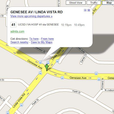
What's a really neat feature is the ability to see where all of the bus stops and Trolley stations are in the MTS service area. If you go to Google Maps and zoom into the map near where you're starting or where you're going, you will see the bus and trolley icons. If you click on the icons, Google Maps will tell you what the next scheduled time the bus departs at that bus stop or trolley station! In San Diego, you can also turn on the Transit Layer to see if transit goes near your origin or destination.

Try it out. It is also available on most mobile phones with the Google Maps application, or on the Maps application on the iPhone (through iOS5).

Sunday, May 13, 2007

Regional Transit Map

Did you know that the San Diego Metropolitan Transit System (MTS) has new regional transit maps good for the entire San Diego County, including NCTD? They're dated June 2007 and take into account all of the recent changes they made to the system.

They are always hard to come by, but if you send $1 to MTS, they'll send you back a map!

Send your $1 and your return address to:

MTS Marketing Department
Regional Transit Map Request
1255 Imperial Ave, Suite 1000
San Diego, CA 92101